Amendments and Revisions
|
|
New Online LOMC User Without an Existing Login.gov Account
Users with an Existing Login.gov Account
For returning Online LOMC users with Login.gov accounts: Returning Online LOMC users who already have Login.gov accounts will be able to access Online LOMC accounts via Login.gov with the same email address used to register their Online LOMC account. If you are unable to access your Online LOMC account via Login.gov, this may be because your Login.gov account is registered under a different email than your Online LOMC account.
If access problems persist, please contact Risk MAP outreach via email at FEMA-RiskMAP-ITHelp@fema.dhs.gov.
Returning Online LOMC User Without an Existing Login.gov Account
If you are unsure what email address you used to register your Online LOMC account with, contact the Risk MAP IT Help Desk via email at FEMA-RiskMAP-ITHelp@fema.dhs.gov.
Forgot Online LOMC Password
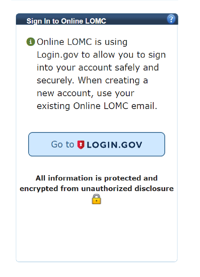
What is Login.gov?
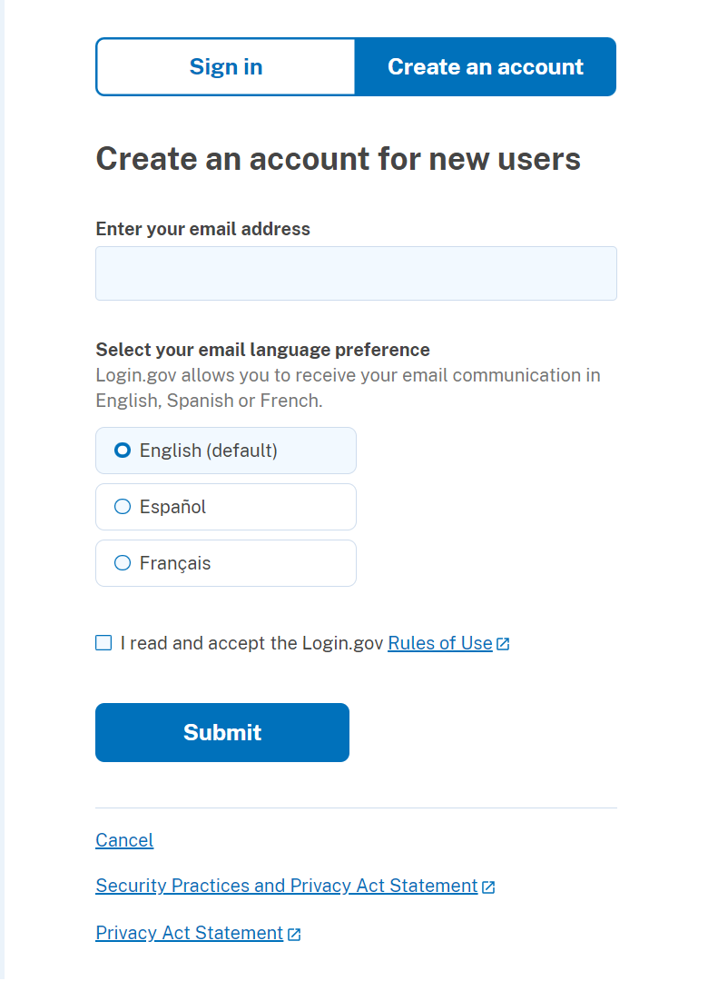
You will need to create a Login.gov account if you do not have one already.
- Go to "Create an Account" and enter your email address. For returning users, use the same email address you used for your Online LOMC account so the accounts can be linked.
- Check your email for a link sent from Login.gov to confirm your email address. To continue creating an account, you will click on the "Confirm email address" button.
- Create a strong password for your Login.gov account that has 12 or more characters.
- Select two multifactor authentication (MFA) methods for added security. Select this link for more information
Now that your Login.gov account has been created, click on the link "Continue to Online LOMC" to be re-directed to the Online LOMC Homepage.
If you forgot your password, go to Reset password | Login.gov and enter your email address. An email will be sent to you with a link to reset your password. Follow the link to continue resetting your password.
Did not receive an email the first time? Click on the "Resend" button and Login.gov will send you another password reset email.
In addition to your password, Login.gov requires that you set up at least one authentication method to keep your account secure. This is multifactor authentication (MFA). Login.gov uses MFA as an added layer of protection to secure your information.
Login.gov offers the following authentication methods:
- Text message or phone call
- Backup Codes
- Authentication application
- Security key
- PIV or CAC for federal government employees and military
Remember that each time you log into your Online LOMC account, you will have to use one of the authentication methods you selected when creating your Login.gov account.
LOMC Home Page Instructions:
This is the primary Online LOMC Homepage. Here, you can:
- Create a new Online LOMC web application, including an amendment request and/or revision request
- View and track the progress of new or previous Online LOMC requests
- Update your Online LOMC profile
- Address questions regarding the Online LOMC process
- Contact the FEMA Risk MAP program should you have any additional questions or concerns.
Create an Application
Not sure of the type of LOMC you want to submit? Use the table below to determine what type of application you should complete.
Table: Which Application Should I Choose?
| Description | Amendment Application | Revision Application |
|---|---|---|
| Typically for Who? | Homeowners, Property owners, Financial Lenders, Community Developers and Officials | Engineers, Surveyors, Community Developers and Officials |
| What Does the Application Entail? | Pertains to a small area of high ground (a property or structure) located within a Special Flood Hazard Area (SFHA) | Involves requesting revisions to effective Flood Insurance Study (FIS) reports, Flood Insurance Rate Maps (FIRMs), or Flood Boundary and Floodway Maps (FBFMs) |
| Types of LOMCs? |
|
|
As you traverse through each page of an Amendment or Revision
Application, the following buttons may appear on the screen:
- Previous – Saves the changes you have made on the page and takes you to the previous page in the process
- Save – Saves the changes you have made on the page but does not take you to a different page
- Save And Close – Saves the changes you have made on the page and takes you back to the Online LOMC Homepage
- Continue – Saves the changes you have made on the page and takes you to the next page in the process
View and Track Applications
This table includes information of all your Online LOMC applications that have been submitted,
are currently in progress, or that have been previously adjudicated
through the Online LOMC site. If you submitted a request for a LOMC through regular
mail using the paper MT-1, MT-2, MT-EZ forms, or used the eLOMA
application process, those requests will not appear here.
The table lists each application's Application ID, property description (i.e., address), FEMA case number, date the FEMA case was created, and the status of the application.
The "Action" column displays links that will allow you to access a summary of supporting documents where you are able to view details of the application, upload documents, make payments, or continue incomplete Online LOMC applications. The "Application ID" also displays as a link that you can click to access a summary of your application.
- Continue – If the applicant previously saved and closed the LOMC application without inputting all of the required information, they can click on "Continue" to proceed through the LOMC application process.
- Delete – If the applicant would like to delete their incomplete Online LOMC application, click "Delete" to remove it from the Online LOMC application process.
- Upload + Pay – If additional data, documentation, and fee payment are requested by the individual responsible for reviewing the Online LOMC application, the applicant may click the "Upload + Pay" option to upload the required documents and submit a payment when requested.
- Pay – If a fee payment is solely requested by the individual responsible for reviewing the Online LOMC application, the applicant can click the "Pay" option to submit an additional payment.
- Upload – If the request for upload of additional data and documentation is requested by the individual responsible for reviewing the Online LOMC application, the applicant can click the "Upload" option in order to submit the required documentation.
- View Detail – For all Online LOMC applications that have been submitted and adjudicated by DHS-FEMA, the applicant can view a summary of the results and the Letter of Final Determination.
The "Status" column displays where you stand in the Online LOMC application process:
- Completed– The applicant's Online LOMC application is complete.
- In Progress–A FEMA Reviewer is currently reviewing the applicant's Online LOMC application.
- Not Submitted–The applicant's Online LOMC application is incomplete and has not been submitted has not been submitted through the Online LOMC system.
- Pending MIP Help–The Online LOMC application process is still pending upon activity in the Online LOMC system.
- Pending E-Check–The applicant's Online LOMC application payment is currently being processed by Pay.gov.
- Removed– The Online LOMC application has automatically been removed due to inactivity and has not been submitted through the Online LOMC system. After 30 days of inactivity, the applicant will receive a warning email stating he or she has 15 days to edit or submit their Online LOMC application. If there is still no activity performed 15 days after the warning email, the applicant's Online LOMC application will be removed.
- Upload–If the applicant previously saved and closed the Online LOMC application without attaching the required documentation to the application, click "Upload" to upload the required documentation.
- Pay– A payment fee is required to process the applicant's Online LOMC application, click on "Pay" to submit a payment.
- Upload + Pay–If the applicant previously saved and closed the Online LOMC application without attaching the required documentation to the application or submitting payment for the application, they can click on "Upload + Pay" to upload the required documentation or enter the information for a fee payment.
- Suspended–A FEMA Reviewer may suspend an Online LOMC application due to missing data, fees, an appeal, or protest.
- Terminated– The Online LOMC application has been removed from the site. This could be due to duplication of applications or the application was determined invalid.
- Under Review– The Online LOMC application submitted and adjudicated by DHS-FEMA is under review for a determined violation of a National Flood Insurance Program (NFIP) regulation. The applicant can view a copy of the violation letter in approximately 6 business days.
- Withdrawn– After an Online LOMC application has been submitted, the applicant may for any reason decide to withdraw their application from the Online LOMC application process. Please contact the FMIX at 1-877-336-2627 or email FEMA-FMIX@fema.dhs.gov to perform this action.
Update Profile
Should you need to update your Online LOMC profile at any time, you can
click on the "Update Profile" link at the top of the homepage and edit
the existing account information as needed.
Frequently
Asked Questions
You can access several web pages to address questions regarding the
Online LOMC process. The Frequently Asked Questions (FAQ) page provides
guidance on specific various DHS-FEMA and LOMC topics. The homepage also
has a link to this Help web page, providing instructions specific to the
use of the Online LOMC site. As you begin to use the Online LOMC web
application to create a LOMC request, you can access these web pages at
any time for guidance throughout the process.
Contact Us
This homepage provides three methods to contact the FEMA Risk MAP
program with any questions or concerns you have regarding the Online
LOMC application process:
- Call the program at 1-877-FEMA MAP
- Email FEMA-FMIX@fema.dhs.gov
- Chat online with a FEMA Map Information eXchange (FMIX) representative
Instructions:
This page highlights information from your current LOMC application,
including general information, community information and a list of the
documents already uploaded and attached to the application. At this
stage in the process, the applicant will need to either attach
additional documents to meet all of the LOMC application requirements or
pay the processing fee.
- To upload new documents, click the Upload button at the bottom of the page.
- To submit a payment for the processing fee, click the Pay button at the bottom of the page.
Having trouble uploading your file?
The Online LOMC web application will not accept the following invalid file extensions: "ade", "adp", "bat", "chm", "cmd", "com", "cpl", "exe", "hta","ins", "isp", "jse", "lib", "mde", "msc","msp", "mst", "pif", "scr", "sct", "shb", "sys", "vb", "vbe", "vbs", "vxd", "wsc", "wsf", "wsh" also ".zip", ".tar", ".tgz", ".taz", ".z", ".gz", ".rar",".htm", ".html". If you receive an error message, please remove the invalid file and try the upload again.
Note: Incomplete submissions will result in
processing delays.
For additional information regarding this form,
including where to obtain supporting documents listed above, please
refer to https://www.fema.gov/mt-1-application-forms-instructions
For any questions regarding what additional information or steps are required to complete your LOMC application, contact the FEMA Map Information eXchange (FMIX) by clicking the Contact Us link at the top of the page.
Update Profile Instructions:
This page allows the applicant to update their account information, password, or challenge questions.
Passwords need to be alphanumeric, contain at least one special character, and be a minimum of eight characters in length.
Once all of the necessary information has been updated, click the Update Profile button at the bottom of the page to save the changes.
Amendments |
Instructions:
DHS-FEMA makes determinations on applicant structures, portions of a parcel of land, or entire legally recorded lots or parcel of land:
Structure
- If the Amendment application is for a structure on a property, the date of construction must be provided in this section. The date of construction must be provided in a MM/YYYY format.
Portion of a parcel (portion of land)
- If the Amendment application request is for a portion of a parcel (portion of land), the applicant must provide a written metes and bounds description, prepared and certified by a licensed land surveyor or professional engineer, for the portion of property to be determined. Please note that the metes and bounds description must be tied to an identifiable starting point. In addition, the applicant must provide a certified map of the metes and bounds area.
Entire legally recorded lot or parcel of land
- If the request is for an entire legally recorded lot or parcel of land, the applicant must ensure that the entire parcel is clearly located outside of the Special Flood Hazard Area or is elevated above the Base Flood Elevation. Please note that the mandatory purchase requirement only applies to those structures on the land securing a federally backed or insured loan; flood insurance cannot be purchased for land.
Number of Structures or Properties
DHS-FEMA makes determinations on single or multiple structures, portions
of a parcel of land, or lots or parcels of land. Select the choice that
best describes your request. For requests that include multiple
structures and/or lots, note how many structures and/or lots are
included in the request.
Instructions:
The applicant needs to include the address and legal description of each
structure or property included within this application.
Street Address of the Property
- Enter the street address for the structure or property being reviewed.
- NOTE: This address needs to must be the address for the exact property location and should not be for any temporary or separate location address (e.g., PO Box, home or address location of applicant if different from the property under review subject location).
Legal Description of Property
- Describe the property by referring to the Deed or Plat Map. The description may consist of a lot number and subdivision name, a parcel number, a tract number, or any other information provided in the Deed or Plat to identify the property (e.g. Lot 2, Block 1, Floodville Estates). It is not necessary to reproduce a lengthy description of the property as it appears in the Deed. You may find your Deed or Plat Map filed with your local municipal town or city hall.
Adding Multiple Properties
- Once all of the information for the structure or property has been completed, select "Add Property" and the input will be listed in at the bottom of the page. If the request includes multiple structures and/or lots, complete the requested information for each structure and/or lot.
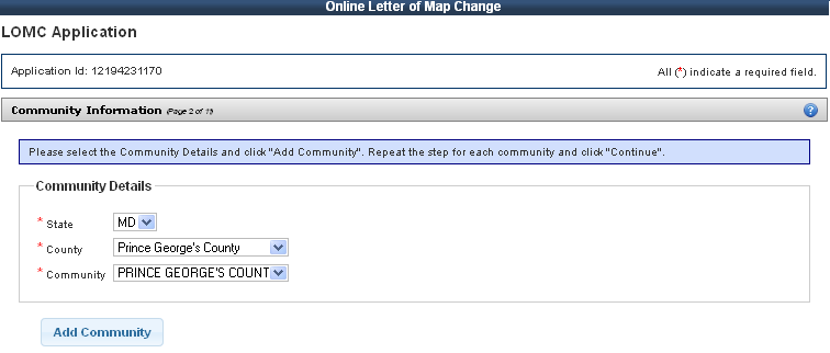
Instructions:
Community Information
Please select each of the following from the menu:
- State
- County
- Community
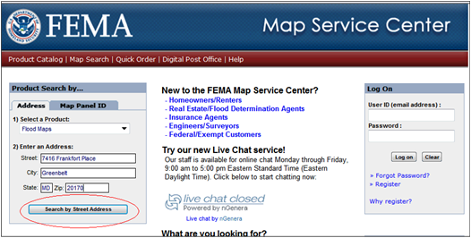
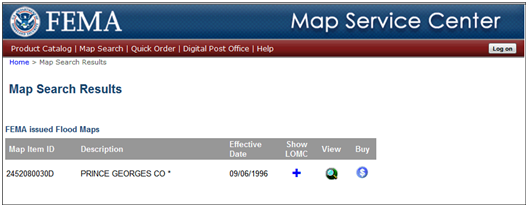
How do I find my Community?
Use the Map Service Center (MSC) website to assist you in finding your community. Select this link.
Use the following directions to guide you through the process:
- Type the property address and click "Search by Street Address" from the MSC site.
- On the results page, click the "View" button.
- Note: If you do not see a map, choose the
closest community from the Online LOMC web application community
drop-down box. (See example in figure below)
- Note: A FEMA engineer will contact the applicant if the information provided does not match any supporting document so that a correct determination can be made.
- Note: If you do not see a map, choose the
closest community from the Online LOMC web application community
drop-down box. (See example in figure below)
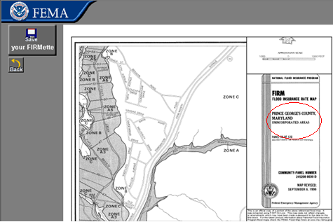
- A map will display. Click the "Make a FIRMette" button
- In the bottom right corner of the FIRMette, you can locate the State, County, and Community information. Please use this information to enter into the Online LOMC tool.

Instructions:
Fill is defined as material from any source (including the subject property) placed on the property that raises the ground (natural grade) to or above the Base Flood Elevation (BFE).
The common construction practice of removing unsuitable existing material (topsoil) and backfilling with select structural material is not considered the placement of fill if the practice does not alter the existing (natural grade) elevation, which is at or above the BFE. If the fill was placed before the date of the first National Flood Insurance Program (NFIP) map showing the area in a Special Flood Hazard Area, the area that would be inundated by the base flood, is considered natural grade.
Regardless of the type of LOMC being requested, DHS-FEMA requires the applicant to confirm, to the best of his or her knowledge, whether fill was or was not placed on the property. The applicant must select either "yes" or "no". If fill was placed on the property, the applicant must provide the month and year fill was placed.
If fill has not been placed on the property to raise ground that is below the BFE, DHS-FEMA requires the applicant to confirm whether they plan for fill to be placed on the property in the future by selecting "yes" or "no". If fill will be placed on the property, the applicant must provide the month and year fill will be placed.
IMPORTANT: CLOMR-F applicants are responsible for documenting to FEMA that Endangered Species Act (ESA) compliance has been achieved prior to FEMA's review of a CLOMR-F application. ESA compliance may be documented by submitting to FEMA a copy of an Incidental Take Permit, an Incidental Take Statement, a "not likely to adversely affect" determination from the National Marine Fisheries Service (NMFS) or the U.S. Fish and Wildlife Service (USFWS), or an official letter from NMFS or USFWS concurring that the project has "No Effect" on proposed or listed species or designated critical habitat. The applicant may begin by contacting a NMFS or USFWS office, State wildlife agency office, or independent biologist to identify whether threatened or endangered species exist on the subject property and whether the project associated with the CLOMR-F request would adversely affect species or designated critical habitat. These entities are also available to discuss questions pertaining to listed species and ESA compliance. If potential adverse impacts could occur, then NMFS or USFWS may require changes to the proposed activity and/or mitigation. For CLOMA, LOMA, and LOMR-F requests involving floodplain activities that have occurred already, private individuals and local and state jurisdictions are required to comply with the ESA independently of FEMA's process. These requests do not provide the same opportunity as CLOMR-Fs for FEMA to comment on the project because CLOMAs and LOMAs do not involve a physical modification to the floodplain and because LOMR-Fs are issued only after the physical action has been undertaken in the floodplain. Additional information about the ESA and these requirements is available on https://www.fema.gov/compliance-endangered-species-act-letters-map-change or by requesting a copy from the DHS-FEMA Mapping and Information eXchange (FMIX) toll free at 1-877-FEMA MAP (1-877-336-2627). Although FEMA's staff is not available to assist with this process, NMFS and the USFWS both have staff available around the country to answer questions about threatened and endangered species and ESA compliance.
Assistance to ascertain if fill has been placed on your property may be available from the community official or agency responsible for floodplain management. Requesters should consult with the community map repository to obtain previous editions of the NFIP map, archived topographic data, or permit drawings related to construction on the site. If the structure footprint is located on ground higher than the surrounding area, fill may have been placed. Additional sources for assistance would include the developer or engineer/designer of the subdivision, previous owners of the site, persons who have owned or resided on adjacent parcels, and large scale aerial photographs (check the tax assessor's office). In addition, digital copies of historic NFIP maps may be available on DHS-FEMA's Map Service Center (MSC) for a nominal fee. To place orders from the MSC, interested parties may visit the MSC website at https://www.msc.fema.gov. For additional information regarding historic maps, interested parties should contact the DHS-FEMA Mapping and Information eXchange, toll free, at 1-877-FEMA MAP (1-877-336-2627).
Instructions:
Acknowledge whether a previous LOMC application has been submitted for the property.
Instructions:
Based on the information provided, this page determines which LOMC type
the applicant needs to apply for and the processing fee for the
application.
LOMC Type
The type of LOMC is automatically selected for you based on the online
LOMC process and the answers you have already given.
Processing Fee
The processing fee amount is determined based on the responses you
previously gave in the online LOMC application process. The appropriate
review and processing fee must be submitted for requests involving
proposed projects and for requests involving the placement of fill
(e.g., CLOMA, LOMR-F, or CLOMR-F). No fee is required to obtain a
determination based on existing conditions (i.e. LOMA) as long as no
fill has been placed. For the current fee schedule visits DHS-FEMA's
Flood Map-Related Fees Internet site: https://www.fema.gov/flood-map-related-fees.
Instructions:
The applicant must enter the information of the person who is applying for a LOMC. The address entered should be the mailing address of the applicant, not the address of the property requesting a LOMC (unless both addresses are the same). The email address provided in the Contact Information section will be the primary means of communication between FEMA and the applicant.
Instructions:
Please review and make sure all information on this page is accurate. Also, please print the page for your records.
Instructions:
Based on the responses to your application, you may need to provide a
completed Elevation Form or Elevation Certificate. Click the "Elevation
Form" link to access a PDF version of the form. Print out the form and
take to your local licensed land surveyor or registered professional
engineer to complete and return to you so that you can submit it with
your Online LOMC Amendment application.
- Note: Adobe Acrobat Reader is required to view the PDF files. If you are unable to view the PDF files, download Adobe Acrobat Read here.
Instructions for ALL LOMC Applicants:
Elevation Form
For ALL LOMC applications, the applicants must submit an Elevation Form (DHS-FEMA Form 086-0-26A, FEB11), except requests for determinations in which the FIRM already shows the property to be CLEARLY outside the SFHA. This form must be completed by a licensed land surveyor or registered professional engineer. If the request is to remove the entire legally recorded property, or a portion thereof, the lowest lot elevation must be provided on the Elevation Form.Click here to view an example of an Elevation Map
If the request is to remove the structure, and an Elevation Certificate has already been completed for this property, it may be submitted in lieu of the Elevation Form. The Elevation Certificate must be certified by a licensed land surveyor or registered professional engineer.
How do I complete the Elevation Form? (Select this link)
Instructions for LOMR-F and CLOMR-F Applicants:
Elevation Form
For ALL LOMC applications, the applicants must submit an Elevation Form (DHS-FEMA Form 086-0-26A, FEB11), except requests for determinations in which the FIRM already shows the property to be CLEARLY outside the SFHA. [Should we address this stipulation earlier in the application" How would we do so"] This form must be completed by a licensed land surveyor or registered professional engineer. If the request is to remove the entire legally recorded property, or a portion thereof, the lowest lot elevation must be provided on the Elevation Form.Select this link to view an example of an Elevation Map
If the request is to remove the structure, and an Elevation Certificate has already been completed for this property, it may be submitted in lieu of the Elevation Form. The Elevation Certificate must be certified by a licensed land surveyor or registered professional engineer.
How do I complete the Elevation Form? (Select this link)
Community Acknowledgment Form
The Community Acknowledgment Form (DHS-FEMA Form 086-0-26B, FEB11) must be completed for all requests involving the placement of fill, existing or proposed, or requests for land or structures that are inadvertently included in the NFIP regulatory floodway. The form must be completed and signed by the community official responsible for floodplain management in the community. The community name and the subject property address shown provided earlier in the Online LOMC process must appear in the spaces provided on this form. Space has been provided within each section for the community official to provide comments on the project (e.g., Section A - The project is reasonably safe from flooding and satisfies Parts 60.3 and 65.5 of the NFIP regulations. Section B - Removal of the project from the regulatory floodway will not result in an increase in Base Flood Elevations.). If additional space is required by the community official to provide the community's comments on a project, additional sheets may be added to the back of the form when uploaded to the Online LOMC application.
How to Complete the Elevation Form:
The Elevation Form (DHS-FEMA Form 086-0-26A, FEB11) must be completed by a licensed land surveyor or registered professional engineer (authorized by law to certify the information requested). If the request is to make a determination on the structure, and an NFIP Elevation Certificate has already been completed for this property, it may be submitted in lieu of this form.If the request is to make a determination on the entire legally recorded property, or a portion thereof, the lowest lot elevation must be provided on the Elevation Form. If the request is to have the SFHA designation determined for the entire legally recorded property, but the only elevation provided is the Lowest Adjacent Grade to Structure, the determination will be issued for the structure.
For a licensed land surveyor or registered professional engineer to complete this form, it will be necessary to obtain the effective Flood Insurance Rate Map (FIRM) panel, effective Flood Boundary and Floodway Map (FBFM) panel (if printed), and Flood Insurance Study (FIS) report that cover the area in which the property is located. These can be obtained from the community map repository or ordered from the Map Service Center (MSC), for a nominal fee. To place orders from the MSC, go to their Internet site: https://www.msc.fema.gov.
The DHS-FEMA Map Service Center allows users, including homeowners, surveyors, and engineers, to search the MSC for maps and other technical data. Searches can be conducted under the three following criteria: Catalog, Map Search, and Quick Order. Catalog allows surveyors and engineers to search through the Map Service Center for available data. Map Search allows surveyors and engineers to search for data available for an individually specified map area. Quick Order allows surveyors and engineers to search available data by a specific FIRM panel or Community number. All search criteria will allow surveyors and engineers to search desired data and add that data to a "shopping cart" for later payment options. Payment must be in the form of a credit card. Visa, MasterCard, Discover and American Express are accepted. Surveyors and engineers that do not have Internet access should contact the DHS-FEMA Mapping and Information eXchange by calling 1-877-FEMA MAP (1-877-336-2627). They may fax their map order requests to the MSC at 1- 800-358-9620.
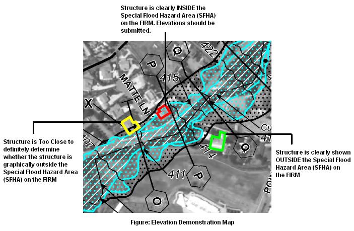
The following graphic is a demonstration of an elevation map. It displays three structures in relation to the Special Flood Hazard Area (SFHA). The yellow structure (far left) is an example of a strucure that is too close to definitely determine whether the structure is graphically outside the Special Flood Hazard Area on the FIRM. The red structure (middle) shows a structure that is clearly inside the Special Flood Hazard Area on the FIRM, therefore elevations should be submitted. The green structure (far right) is clearly shown outside of the Special Flood Hazard Area on the FIRM. Use the map as a guideline to determine the location of your property or structure in relation to the Special Flood Hazard Area. If your property or structure is clearly outside of a Special Flood Hazard Area, you may not have to submit the Elevation Form. Please be aware, not submitting this form will delay the processing of your request.
Number 1 – Community Number
Provide the six digit NFIP community number as it appears in the Title Block of the FIRM panel. In addition, include the name of the property (i.e. legal description) and/or the property's address.
For additional information on reading FIRM panels you may consult the tutorial "How to Read a FIRM" on DHS–FEMA's Internet site: https://www.fema.gov/media/fhm/firm/ot_firm.htm.
NOTE: In some communities, the only NFIP maps available may be Flood Hazard Boundary Maps, instead of FIRMs.
Number 2 – Conditionals
Identify whether the elevations being provided are based on existing or proposed conditions.
Number 3 – Type of Construction
If the request involves or will involve a structure, provide the type of construction.
Crawl Space – The bottom floor is below the first floor, is enclosed by solid and partial perimeter walls, and may be above ground level (grade) on one or more sides. Spaces below ground level on all sides must meet the requirements of FEMA Technical Bulletin 11-01. Spaces with a bottom floor elevation more than 2.0 feet below the Lowest Adjacent Exterior Grade (LAG) elevation will be classified as a basement.
Slab on Grade – The bottom floor is at or above ground level (grade) on at least one side.
Basement/Enclosure – The bottom floor (basement or underground garage) is below ground level (grade) on all sides. See Crawl Space above.
Other – All other structure types not listed above including, but not limited to split levels, structures on piers, mobile homes, etc. Please be as detailed as possible.
Number 4 – Elevation Datum
Provide the elevation datum (e.g., NGVD 29, NAVD 88, or other specified)
for which the property elevations shown on the form are referenced. If
the datum being referenced is different than the datum used to produce
the effective FIS, please provide the datum conversion. Please note that
mean sea level datum (MSL) is used within the Commonwealth of Puerto
Rico and local tidal datum (LTD) is used within the U.S. Virgin Islands.
Number 5 – Geographic Coordinate Data
The surveyor or engineer must provide the latitude and longitude of the
property in decimal degrees to the 5th decimal place (00.00000), and
indicate the appropriate horizontal datum, WGS84, NAD83, or NAD27.
Number 6 – Subsidence or Uplift
Land subsidence is the lowering of the ground as a result of water, oil, gas extraction, as well as other phenomena such as soil compaction, decomposition of organic material, and tectonic movement. Periodically, the National Geodetic Survey re-levels some benchmarks to determine new elevations above the National Geodetic Vertical Datum of 1929 (NGVD 29) or above the North American Vertical Datum of 1988 (NAVD 88); however, not all benchmarks are re-leveled each time.
Check "yes" if the area of the property is in an area of subsidence or uplift, and provide the date of the current re-leveling; check "no" if the area of the property is not in an area of subsidence or uplift. In areas experiencing ground subsidence (e.g., Harris County, Texas, and Incorporated Areas); the most recently adjusted Elevation Reference Mark (ERM) must be used for accurate ground and structure elevations. Please consult the effective Flood Insurance Study (FIS) for your community or local floodplain administrator for the most current ERM data.
In general, the effects of subsidence can be accounted for by determining grade and structure elevations using benchmark elevations with the same re-level date as the benchmarks used to develop the Base (1%-annual chance) Flood Elevations (BFEs) on the FIRM. Please be aware that benchmark re-level dates can be different for different flooding sources. No adjustment is necessary to the BFEs on the FIRM.
Elevation Table
A row in the elevation table must be completed for each property (parcels of land or structures) involved in this request (subject property).
Address – Provide the street address (911 type) for subject property.
Lot/Block Number – Provide the property's lot and/or block number if available. In the absence of a lot or block number, the registered professional engineer or licensed land surveyor must include an identifier that clearly states for what the elevations are being referenced (e.g. residential structure, commercial building, unit 1, etc.).
Lowest Lot Elevation – For requests involving property, or a portion thereof, provide the lowest lot elevation to the nearest tenth (0.1) of a foot or meter. If the FIRM shows BFEs in meters, the accuracy of the lowest lot elevation must be to the nearest tenth of a meter. If the BFE varies across the property, please provide a certified site plan showing the range of elevations across the property.
Lowest Adjacent Grade (LAG) to the Structure – For requests involving a structure, provide the LAG elevation (the elevation of the lowest ground touching the structure including attached patios, stairs, deck supports or garages), to the nearest tenth (0.1) of a foot or meter. If the FIRM shows BFEs in meters, the accuracy of the LAG elevation must be to the nearest tenth of a meter.
Base Flood Elevation – Provide the BFE affecting the property. FEMA will verify the BFE during the review process. BFEs can be obtained by locating the property on the effective FIRM for the community in which the property is located. Upon locating the property on the FIRM, the engineer or surveyor should determine the type of flooding and in which flood zone the property is located. The summary below will provide direction for how to determine the BFE as a result of the flooding type and flood zone determination.
Base Flood Elevation Source –Provide the source used in determining the BFE (e.g. FIRM, profile, floodway data table, Community Determined, or other source). When submitting a BFE that is either community determined or from an alternate source, please include in the request, sufficient data that supports the BFE.
- Riverine Flooding Systems (Zones AE or A1-A30) – Consult the FIS report for the community in which the property is located. Next, locate the flood profile for the flooding source by name. Estimate the property"s location along the flood profile and interpolate the BFE using the 100-yr. flood profile line.
- Lacustrine (Stillwater) Flooding Systems –Consult the FIS report for the community in which the property is located. Next, locate the Summary of Stillwater Elevations table. Locate the flooding source, by name, and use the BFE listed in the table. The flooding source's BFE is normally shown to the nearest one-tenth of a foot. If the flooding source is not listed in the "Summary of Stillwater Elevations" table, use the BFE as shown on the FIRM.
- Coastal Flooding Systems (Zones AE or A1-A30 and VE or V1-V30) –First, obtain the BFE from the FIRM panel. Next, consult the FIS report for the community in which the property is located. Locate the Summary of Stillwater Elevations table in the FIS report. Identify the flooding source, by name, and use the BFE listed in the table. Compare the BFE listed in this table to the BFE obtained from the FIRM. If the stillwater elevation listed in this table is less than or equal to the whole-foot BFE shown on the map minus 0.5 foot, a wave height, wave run-up, and/or wave setup component exists. In this case, the whole-foot BFE shown on the map should be used for rating, construction, and floodplain management purposes. If the stillwater elevation listed in the "Summary of Stillwater Elevations" table is greater than the wholefoot BFE shown on the map minus 0.4 foot, the stillwater elevation shown in the table shall be used as the BFE. (Any property/structure located seaward of the landward toe of the primary frontal dune may not be removed from a Zone VE or V1-V30).
- Zone A Flooding –If the property is located in a Zone A, an area of approximate flooding with no BFEs determined, a BFE will need to be determined by the engineer or surveyor. First, the engineer or surveyor should determine if a Federal, State, or local government agency has developed a BFE. Such agencies include the U.S. Army Corps of Engineers, the U.S. Geological Survey, the State's Department of Natural Resources, Department of Environmental Quality, or Department of Transportation; or the local Planning and Zoning Department. If one has been developed, all supporting data and calculations used to develop the BFE must be submitted, or a letter directly from the government agency must be submitted. If a BFE has not previously been developed, the engineer or surveyor should consult DHS-FEMA 265, Managing Floodplain Development in Approximate Zone A Areas: A Guide for Obtaining and Developing Base (100- year) Flood Elevations, available online at https://www.fema.gov/resource-document-library. This publication is an excellent resource, which details the appropriate methods for determining BFEs in SFHAs designated flood zone A. To obtain additional information about developing BFEs, contact the DHS-FEMA Mapping and Information eXchange at 1-877-FEMA MAP (1-877-336-2627). If the property is greater than 50 lots or 5 acres, whichever is the lesser, the engineer or surveyor must determine a BFE as a provision of Part 60.3(b)(3), which is available online at https://www.fema.gov/media-library/assets/documents/12442.
- Shallow Flooding (Zone AH) – If the property is located in flood zone AH, locate the Summary of Stillwater Elevations table in the FIS report. Identify the flooding source, by name, and use the BFE listed in the table. If no Summary of Stillwater Elevations table exists, use the BFE shown on the FIRM. If different elevations appear within the same SFHA, the BFE is obtained by linear interpolation between two adjacent BFE lines.
- Shallow/Sheet Flooding (Zone AO) – For a property located in Zone AO, the characteristics of the Zone AO area shown on the NFIP map will determine the appropriate methodology to be used to develop the BFE for the property. If the flooding is conveyed by the street, provide the highest top of curb or crown of street elevation (whichever is higher) along the property line and add this to the depth of flooding. The lowest adjacent grade elevation must be above the curb or street elevation by an amount equal to or greater than the depth of flooding shown on the NFIP map. If the entire property is inundated by the SFHA and the flow is not conveyed by the street, add the depth of flooding to the average surrounding grade. If the property is partially inundated by the SFHA and the street does not convey the flow, add the depth of flooding to the lowest lot elevation. Along with the information required for one of the abovementioned methods, provide sufficient certified topographic information, including flow paths, to show that the structure is located on high ground relative to the depth indicated on the NFIP map. If the request involves multiple properties (parcels of land or structures), elevations must be provided for each property. If the number of properties for which DHS-FEMA is to make a determination exceeds the number of rows on the Elevation Table, additional photocopies of the table may be attached to the back of the Elevation Form.
Certification (by a licensed land surveyor, registered professional engineer, or architect)
The certifier must provide his or her name, license number and expiration date, his or her company name, telephone number and, if applicable, his or her fax number and email address. The certifier's seal, if available, may be provided here. The certifier must sign and date the Elevation Form, where indicated, to certify the accuracy of the information provided. Not all states authorize architects and engineers to certify elevation information. Consult the state board of registration for more information.
Instructions:
In addition to the information provided, applicants need to upload the
following documents for ALL LOMC requests:
- Copy of the effective FIRM panel (including the Title Block) that shows the area in which the property is located. The FIRM should be available at the community map repository or from the community official or agency responsible for floodplain management. However, digital copies of the FIRM Index and FIRM panels may be ordered from the Map Service Center (MSC), for a nominal fee. To place orders from the MSC, go to their website: https://www.msc.fema.gov. A FIRMette, which can be printed free of charge from the MSC website, may be submitted in lieu of a copy of the FIRM. If your community has a separate Flood Boundary and Floodway Map (FBFM), please include a copy.
- Copy of the Subdivision Plat Map for the property (with recordation data and stamp of the Recorder's Office), AND Copy of the Tax Assessor's Map or other certified map showing the surveyed location of the property relative to local streets and watercourses. The recordation data (e.g., Book, Volume, Page, Reel, Document Number, and Date) must be evident on the copies of these documents so that DHS-FEMA can use the legal description of the property. In addition, DHS-FEMA must be able to identify the property exactly. If the property is not recorded on a Plat Map, a copy of a tax assessor's map or other suitable map must be submitted to aid DHS-FEMA in locating the property. The map should include at least one street intersection that is shown on the FIRM panel.
OR
- Copy of the Property Deed (with recordation data and stamp of the Recorder's Office) AND Copy of the Tax Assessor's Map or other certified map showing the surveyed location of the property relative to local streets and watercourses. The recordation data (e.g., Book, Volume, Page, Reel, Document Number, and Date) must be evident on the copies of these documents so that DHS-FEMA can use the legal description of the property. In addition, DHS-FEMA must be able to identify the property exactly. If the property is not recorded on a Plat Map, a copy of a tax assessor's map or other suitable map must be submitted to aid DHS-FEMA in locating the property. The map should include at least one street intersection that is shown on the FIRM panel.
Endangered Species Act (ESA)
CLOMR-F applicants are responsible for documenting to FEMA that Endangered Species Act (ESA) compliance has been achieved prior to FEMA's review of a CLOMR-F application. ESA compliance may be documented by submitting to FEMA a copy of an Incidental Take Permit, an Incidental Take Statement, a "not likely to adversely affect" determination from the National Marine Fisheries Service (NMFS) or the U.S. Fish and Wildlife Service (USFWS), or an official letter from NMFS or USFWS concurring that the project has "No Effect" on proposed or listed species or designated critical habitat. The applicant may begin by contacting a NMFS or USFWS office, State wildlife agency office, or independent biologist to identify whether threatened or endangered species exist on the subject property and whether the project associated with the CLOMR-F request would adversely affect species or designated critical habitat. These entities are also available to discuss questions pertaining to listed species and ESA compliance. If potential adverse impacts could occur, then NMFS or USFWS may require changes to the proposed activity and/or mitigation.
For CLOMA, LOMA, and LOMR-F requests involving floodplain activities that have occurred already, private applicants and local and state jurisdictions are required to comply with the ESA independently of FEMA's process. These requests do not provide the same opportunity as CLOMR-Fs for FEMA to comment on the project because CLOMAs and LOMAs do not involve a physical modification to the floodplain and because LOMR-Fs are issued only after the physical action has been undertaken in the floodplain.
Scanning Large Documents/Submission of Oversized Data FilesIs your physical document too large to scan? (e.g. oversized map) Please mail your supporting document(s) to the LOMC Clearinghouse address below. Be sure to include your Application ID and FEMA Case Number (provided on the LOMC Home page of the Online LOMC web application) in reference to your Online LOMC submission. Please note that your documents WILL NOT be returned.
File packages less than 1 gigabyte (GB) in size can be uploaded. Any packages greater than 1 gigabyte (GB) in size or containing more than 8,000 files should be separated into multiple uploads or transferred to a CD, DVD, or Hard Drive and mailed to the LOMC Clearinghouse. Important: Please ensure to include the Online LOMC Application ID and FEMA Case Number when sending oversized data files to the LOMC Clearinghouse.
LOMC Clearinghouse
3601 Eisenhower Ave Ste 500,
Alexandria, VA 22304-6426
Important: When mailing document(s) to the LOMC Clearinghouse, please include the amendment application case number.
Instructions:
Read the Penalty Clause. Once you have read and understand the Penalty Clause, check the box acknowledging that you have provided truthful information and click "Initiate Project".
Instructions (Only if fee is required for the application):
Enter the required credit card or E-Check information in the fields provided. Once all of the fields are completed, click the "Payment Confirmation" button to confirm payment information. You will then be directed to the Payment Confirmation screen. Review your payment details to ensure accuracy. To make changes to your payment information, click the "Previous" button. Otherwise, click the "Make Payment" button to begin the payment approval process. If payment is submitted by E-Check, a case number will not be immediately generated. Once the payment is processed (typically in approximately three to five business days), a case number will be generated and DHS-FEMA will begin reviewing your Online LOMC application.
The processing fee amount is determined based on the responses you previously gave in the online LOMC application process. The appropriate review and processing fee must be submitted for requests involving proposed projects and for requests involving the placement of fill (e.g., CLOMA, LOMR-F, or CLOMR-F). No fee is required to obtain a determination based on existing conditions (i.e. LOMA) as long as no fill has been placed. For the current fee schedule visit DHS-FEMA's Flood Map-Related Fees website: https://www.fema.gov/flood-map-related-fees.
Bank Account and Routing Numbers
In order to pay directly from your bank account, you'll need to provide us with your bank account number and bank routing number. You will find both of these numbers on the checks issued for your account.
Routing numbers are always 9 digits long. Account numbers may be up to 17 digits long. Some banks list the routing number first on the check, while other banks list the account number first.
Revisions |
Project Name/Identifier
The user must create a project name or designate an identifier that will help describe the project. This can be the name of a flood control project or other pertinent structure having an impact on the effective Flood Insurance Study (FIS) report, a subdivision or area, or some other identifying phrase. The Project Name/ Identifier may be up to 128 characters.
Revision Project Type
This project application is applicable for the following
requests:
- Conditional Letter of Map Revision (CLOMR): A letter from FEMA commenting on whether a proposed project, if built as proposed, would justify a map revision, or proposed hydrology changes. The letter does not revise an effective National Flood Insurance Map (NFIP), it indicates whether the project, if built as proposed would be recognized by FEMA.
- Letter of Map Revision (LOMR): A letter from FEMA officially revising the current NFIP map to show the changes to floodplains, regulatory floodway or flood elevations. LOMRs are generally based on the implementation of physical measures that affect the hydrologic or hydraulic characteristics of a flooding source and thus result in the modification of the existing regulatory floodway, the effective Base Flood Elevations (BFEs), or the Special Flood Hazard Area (SFHA).
- Letter of Map Amendment (LOMA)
- Conditional Letter of Map Amendment (CLOMA)
- Letter of Map Revision Based on Fill (LOMR-F)
- Conditional Letter of Map Revision Based on Fill (CLOMR-F)
This Online LOMC application is not applicable for the following requests:
For these requests, please return to the Online LOMC Homepage to create an Amendment Application.
Select your community or communities of interest through the pull down menus. After selecting your community of interest, select the appropriate National Flood Insurance Program (NFIP) map panel(s), also known as a Flood Insurance Rate Map (FIRM) panel. The user has the option to select multiple NFIP panels, the same NFIP map panel, however may not be selected twice. If the NFIP map panel is listed under different community names, for example, the City of Smithfield and County of Smithfield, you may select both of these NFIP map panels.
A NFIP map panel is the official map of a community on which FEMA has delineated both the special hazard areas and the risk premium zones applicable to the community. If you need help finding your community, use the Map Service Center (MSC) website to find your community. Follow the steps below to guide you through this process:
- Go to the Map Service Center(MSC) website at https://www.msc.fema.gov
- Type the property address and select "Search by Street Address"
- On the Map Search Results page, click the "View" button.
- A map will appear. Select the "Make a FIRMette" button
- In the bottom right corner of the FIRMette, you can locate the State, County, and Community information. Please use this information to enter into the revision request.
Scanning Large Documents/Submission of Oversized Data Files
File packages less than 1 gigabyte (GB) in size can be uploaded. Any packages greater than 1 gigabyte (GB) in size or containing more than 8,000 files should be separated into multiple uploads or transferred to a CD, DVD, or Hard Drive and mailed to the LOMC Clearinghouse. Please ensure to include the Online LOMC Application ID and FEMA Case Number when sending oversized data files to the LOMC Clearinghouse.
Locate the NFIP map panel(s) you wish to revise and select the "Add" button. Use the "Remove" button to delete your selection. As a second option, you may also manually enter the map panel number and the effective date if you do not see your NFIP map panel. However, both "Map Panel Number" and "Other Map Number" cannot be selected at the same time.
If you are uploading multiple NFIP map panels, select all that are applicable to your revision request. You may select multiple map panels for your community, as long as the selected map panels are within your FEMA region. For example, you may not select a map panel in Connecticut and a map panel in Virginia. However, you may select a map panel in Virginia and Pennsylvania because they are within the same FEMA region. Below describes all FEMA regions and associated states:
| FEMA Regions | Associated States |
|---|---|
| Region 1 | CT, MA, ME, NH, RI, VT |
| Region 2 | NJ, NY, PR (Puerto Rico), VI (U.S. Virgin Islands) |
| Region 3 | DC, DE, MD, PA, VA, WV |
| Region 4 | AL, FL, GA, KY, MS, NC, SC, TN |
| Region 5 | IL, IN, MI, MN, OH, WI |
| Region 6 | AR, LA, NM, OK, TX |
| Region 7 | IA, KS, MO, NE |
| Region 8 | CO, MT, ND, SD, UT, WY |
| Region 9 | AZ, CA, HI, NV, GU, AS, CNMI, RMI, FM |
| Region 10 | AK, ID, OR, WA |
NFIP Map Panel(s) not available for selected Community
Communities that do not have associated NFIP map panels are not eligible
to submit the request through the Online LOMC web application. Please
contact the FEMA Mapping and Information eXchange (FMIX) toll free at (877)
336-2627 (877-FEMA-MAP) for inquiries on availability of NFIP Map
Panel(s) for the community of interest.
Flooding Source
A flooding source refers to a specific lake, stream, ocean, etc. This
should match the flooding source name shown on the map panel, if it has
been labeled. Examples of flooding sources include Lake Michigan, Duck
Pond, or Big Hollow Creek.
Types of Flooding
After entering the appropriate flooding source, please select the type
of flooding that affects the area of your revision request. Please
select all that apply to your revision request:
- Riverine Flooding
- Coastal Flooding
- Shallow Flooding
- Alluvial Fan Flooding
- Lakes
- Other (Comments are required for this selection)
The basis of the request will determine what form(s) the requester will need to process the revision request. Below are descriptions for these types of revisions and basis for request:
- Alluvial Fan Analysis – Select this option if the revision request involves alluvial fans. The purpose of this form is to ensure that a structural flood control measure in areas subject to alluvial fan flooding is designed and/or constructed to provide protection from the 1% annual chance flood, in compliance with National Flood Insurance Program (NFIP) Regulation 44 CFR Ch. 1, Section 65.13, before it is recognized on an NFIP map. Elevating a parcel of land or a structure by fill or other means will not serve as a basis for removing areas subject to alluvial fan flooding from an area of special flood hazards. See NFIP Regulation 44 CFR Ch. 1, Section 65.13. Complete engineering analyses must be submitted in support of each section of this form. In addition, it may be necessary to complete other forms relating to specific flood control measures, such as levees/floodwalls, channelization, or dams.
- Base Map Changes – Select this option if the revision request includes updates to non-flood hazard data shown on the map such as transportation features. LOMRs may not be issued solely to reflect base map changes.
- Coastal Analysis – Select this option if the revision request is intended to document the steps taken by the requester in the process of preparing the revised models or analyses and the resulting revised Flood Insurance Study (FIS) information. Refer to the Consolidated Guidelines and Specifications for Flood Hazard Mapping Partners, Appendix D: Guidance for Coastal Flooding Analyses and Mapping, which can be obtained from FEMA's website at https://www.fema.gov/media-library-data/1387816650819-3461f89a518dc03c0ef10165212a08b3/Guidelines_and_Specifications_for_Flood_Hazard_Mapping_Partners_Appendix_D-Guidance_for_Coastal_Flooding_Analyses_and_Mapping_(Apr_2003).pdf, for the wave height analyses and mapping procedures used by FEMA for coastal areas. Wave height, wave run-up, and storm-induced erosion may be analyzed using the program, CHAMP 2.0, which was developed for FEMA. CHAMP 2.0 may be obtained from FEMA's website at https://www.fema.gov/coastal-hazard-analysis-modeling-program-version-20. A list of accepted FEMA coastal models can be found on FEMA's website at https://www.fema.gov/coastal-numerical-models-meeting-minimum-requirement-national-flood-insurance-program.
- Corrections – Select this option if the Revision application displays an error on a previously issued LOMR and requires a correction to the NFIP map panel(s).
- Hydraulic or Hydrologic Analysis – Select this option if your revision request involves new or revised hydrologic and/or hydraulic analyses of rivers, streams, ponds, or small lakes. A separate form should be used for each flooding source.
- Improved Methodology/ Data – Select this option if you are utilizing a different technique (model) or have made adjustments to models used in the effective FIS. For revisions based on alternative methodologies or improved data, an explanation as to why the alternative methodology or improved data provides better results over the FIS must be presented and supported.
- Levee Certification – Select this option if your revision request involves a levee that is intended to show the area behind it with a reduced risk. A Levee certification is the process that deals specifically with the design and physical condition of the levee, and is the responsibility of the levee owner or community in charge of the levee's operations and maintenance. Certification must be completed for the levee to be eligible for accreditation by the Federal Emergency Management Agency (FEMA). Certification consists of documentation, signed and sealed by a registered Professional Engineer, as defined in Chapter 44 of the Code of Federal Regulations (44 CFR), Section 65.2. This documentation must state the following:
- The levee meets the requirements of 44 CFR, Section 65.10
- The data is accurate to the best of the certifier's knowledge
- The analyses are performed correctly and in accordance with sound engineering practices
This documentation is provided to FEMA to demonstrate that a registered Professional Engineer certified the levee, and meets the specific criteria and standards to provide risk reduction from at least the one-percent-annual-chance flood. Once the levee meets the other requirements of 44 CFR 65.10, FEMA can accredit the levee and show the area behind it as being a moderate-risk area on a Flood Insurance Rate Map (FIRM). If a community or levee owner wants the area behind a levee to be shown as reducing risk from the one-percent-annual-chance flood, they must first complete the process for having the levee certified.
- Natural Changes– Select this option if the Revision application includes any natural changes, including erosion, subsidence, bridge/ culvert removal, etc. to the NFIP map panel(s).
- New Topographic Data– Select this option if the Revision application involves any revised or improved topographic information to the NFIP map panel(s). New topographic data must be registered by a professional engineer or licensed surveyor.
- Physical Change– Select this option if your request includes any man–made changes, watershed development, flood control structures, etc. Note that fees will be assessed for FEMA's review of proposed and "as-built" projects, as outlined in NFIP regulations 44 CFR Ch. 1, Part 72.
- Regulatory Floodway Revision– Select this option if there is an effective regulatory floodway, or it is the community's intent to establish a regulatory floodway. Regulatory floodway means the channel of a river or other watercourse and the adjacent land areas that must be reserved in order to discharge the base (100-year) flood without cumulatively increasing the water surface elevation more than a designated height. Please include an encroachment analysis of the base flood with your application.
- Weir– Dam Changes–Select this option if the Revision application involves changes to the NFIP map panel(s) from weirs or dams.
- Reissuance– Select this option if a previously issued LOMR was not incorporated into newly issued maps. LOMRs along flooding sources that have been restudied will usually not be able to be reissued.
- Other– Select this option if the Revision application involves any basis for the request not included in the above items.
Refer to the map panel(s) you previously selected when selecting the appropriate flood zone designation(s) affected. Below are descriptions of the FEMA flood zones:
| Zone Designations | Zone Descriptions |
|---|---|
| A | Areas with a 1% annual chance of flooding and a 26% chance of flooding over the life of a 30-year mortgage. Because detailed analyses are not performed for such areas, no depths or base flood elevations are shown within these zones. |
| AH | Areas with a 1% annual chance of shallow flooding, usually in the form of a pond, with an average depth ranging from 1 to 3 feet. These areas have a 26% chance of flooding over the life of a 30-year mortgage. Base flood elevations derived from detailed analyses are shown at selected intervals within these zones. |
| AO | River or stream flood hazard areas, and areas with a 1% or greater chance of shallow flooding each year, usually in the form of sheet flow, with an average depth ranging from 1 to 3 feet. These areas have a 26% chance of flooding over the life of a 30-year mortgage. Average flood depths derived from detailed analyses are shown within these zones. |
| A1-A30 | These are known as numbered A Zones (e.g., A7 or A14). This is the base floodplain where the FIRM shows a BFE (old format). |
| A99 | Areas with a 1% annual chance of flooding that will be protected by a Federal flood control system where construction has reached specified legal requirements. No depths or base flood elevations are shown within these zones. |
| AE | The base floodplain where base flood elevations are provided. AE Zones are now used on new format FIRMs instead of A1-A30 Zones. |
| AR | Areas with a temporarily increased flood risk due to the building or restoration of a flood control system (such as a levee or a dam). Mandatory flood insurance purchase requirements will apply, but rates will not exceed the rates for unnumbered A zones if the structure is built or restored in compliance with Zone AR floodplain management regulations. |
| V | Coastal areas with a 1% or greater chance of flooding and an additional hazard associated with storm waves. These areas have a 26% chance of flooding over the life of a 30-year mortgage. No base flood elevations are shown within these zones. |
| V1-V30 | Coastal areas with a 1% or greater chance of flooding and an additional hazard associated with storm waves. These areas have a 26% chance of flooding over the life of a 30-year mortgage. Base flood elevations derived from detailed analyses are shown at selected intervals within these zones. |
| VE | Coastal areas with a 1% or greater chance of flooding and an additional hazard associated with storm waves. These areas have a 26% chance of flooding over the life of a 30-year mortgage. Base flood elevations derived from detailed analyses are shown at selected intervals within these zones. |
| B | Area of moderate flood hazard, usually the area between the limits of the 100-year and 500-year floods. Are also used to designate base floodplains of lesser hazards, such as areas protected by levees from 100-year flood, or shallow flooding areas with average depths of less than one foot or drainage areas less than 1 square mile. |
| C | Area of minimal flood hazard, usually depicted on FIRMs as above the 500-year flood level. |
| D | Areas with possible but undetermined flood hazards. No flood hazard analysis has been conducted. Flood insurance rates are commensurate with the uncertainty of the flood risk. |
| X Shaded | Area of moderate flood hazard, usually the area between the limits of the 100-year and 500-year floods. Are also used to designate base floodplains of lesser hazards, such as areas protected by levees from 100-year flood, or shallow flooding areas with average depths of less than one foot or drainage areas less than 1 square mile. |
| X Unshaded | Area of minimal flood hazard, usually depicted on FIRMs as above the 500-year flood level. |
Depending on your revision request, the requester must select all applicable structures that encompass the area of revision.
Please note: "No Project" means the revision request is based solely upon the submission of more detailed data. If any man-made modifications have occurred within the revision area since the date of the effective study, the appropriate structure(s) should be selected.
Depending on your selection when starting the Revision application, the project type should already be selected for the requester.
The processing fee amount is determined based on the responses you previously entered in the Revision application. The Processing Fee Table (shown on the Processing Fee Information page) illustrates the current fee schedule for the reviewing and processing of Conditional Letter of Map Revision (CLOMR) and Letter of Map Revision (LOMR) requests. Some revision applications may be exempt from fees, including a request based on a federally funded project (greater than 50%) and a request based solely on submission for more detailed data.
Please select the appropriate processing fee. By selecting the wrong processing fee will delay FEMA's processing of your Revision application.
Applicant information will be the primary contact requesting the Revision application. The information and email address entered will be the primary means of communication between the primary contact and FEMA. If you are a Licensed Engineer who is completing this application on behalf of another individual, please use your mailing address and your contact information, not the address of the property requesting the revision.
Additional Contact(s) information:
To include additional contacts or other interested parties who may want
to receive information regarding your revision request, please add
contact information in this section by selecting the "Add Additional
Contacts" button.
There must be one community official listed for each community selected. If the system did not generate or incorrectly generated community official information, please enter your community official's information in the provided spaces. If you do not know your community official's information, please contact your local community, Mayor's office, or the FEMA Mapping and Information eXchange (FMIX) for further support. To contact the FMIX, please call 1-877-336-2627 or email FEMA-FMIX@fema.dhs.gov.
When entering the community official's contact information, you must enter either an email address or phone number, or both.
The Revision Review page is a summary of your revision request. Please ensure all your responses are accurate. If changes are needed, please select the "Previous" button to navigate back to the page you need to update or change.
Important: You must print this page in order to obtain signatures from your community official and Registered Professional Engineer and/or Land Surveyor. When you print out the Revision Review Summary, signature lines will be displayed. Once signatures have been obtained, the requester will upload this document in the upload step of your revision request.
Signature and Title of Community Official
The person signing this certification should be the CEO for the community involved in this revision request or an official legally designated by the CEO. If more than one community is affected by the change, the community official from the community that is most affected should sign the form, and letters from the other affected communities should be enclosed. If the community or communities disagree with the proposed revision, a signed statement should be attached to the request explaining the reasons or basis for disagreement.
Under 44 CFR 60.3(a)(2), the community is required to ensure, prior to issuing a floodplain development permit that an applicant has obtained all necessary Federal and State permits related to development. The most commonly required Federal permits are wetlands permits under Section 404 of the Clean Water Act of 1972 and incidental take permits under Section 10 of the Endangered Species Act of 1972. Necessary State permits vary depending on the State. If the community is not sure if a wetlands permit is required, refer the applicant to the U.S. Army Corps of Engineers District Office. If the proposed development impacts on threatened or endangered species or the community is unsure if it does, have the applicant consult with the nearest U.S. Fish and Wildlife Service field office.
Certification by Registered Professional Engineer and/or Land Surveyor
The person certifying this submittal must provide a valid license number and expiration date for their license. If this information is provided, affixing a seal is optional. If a seal is available, however, it may be affixed in the seal box provided on this form. The licensed professional engineer and/or land surveyor should have a current license in the State where the affected communities are located. While the individual signing this form is not required to have obtained the supporting data or performed the analyses, he or she must have supervised and reviewed the work.
A certification by a registered professional engineer or other party does not constitute a warranty or guarantee of performance, expressed or implied. Certification of data is a statement that the data is accurate to the best of the certifier's knowledge. Certification of analyses is a statement that the analyses have been performed correctly and in accordance with sound engineering practices. Certification of structural works is a statement that the works are designed in accordance with sound engineering practices to provide protection from the 1% annual chance flood. Certification of "as-built" conditions is a statement that the structure(s) has been built according to the plans being certified, is in place, and is fully functioning.
Based on the responses in this Revision Application, the system will automatically determine what required form(s) the requester will need to submit for this Revision Application. Select the hyperlinks under "Required Forms" to access and print these documents. Complete the required forms and obtain any applicable signatures. Once the required forms have been saved and completed, the requester will upload these forms on the next page.
In the "Additional Forms" section, are additional forms for a LOMR and CLOMR application. the requester may also print these documents The additional forms for LOMR/CLOMR application can be found in the "Additional Forms" section. You may print these documents in order to obtain required signature(s) regarding this LOMC. Please note that failing to provide these documents as part of this Online LOMC submission may delay the processing of this LOMC.
Please ensure the supporting forms that are appropriate to your revision request are included in your submittal. Check each form that you will include and upload the file. An error will appear if the appropriate form(s) are not included in your submittal.
Scanning Large Documents/Submission of Oversized Data Files
Is your physical document too large to scan? (e.g. oversized map) Please mail your supporting document(s) to the LOMC Clearinghouse address below. Be sure to include your Application ID and FEMA Case Number (provided on the LOMC Home page of the Online LOMC web application) in reference to your Online LOMC submission. Please note that your documents WILL NOT be returned.
File packages less than 1 gigabyte (GB) in size can be uploaded. Any packages greater than 1 gigabyte (GB) in size or containing more than 8,000 files should be separated into multiple uploads or transferred to a CD, DVD, or Hard Drive and mailed to the LOMC Clearinghouse. Important: Please ensure to include the Online LOMC Application ID and FEMA Case Number when sending oversized data files to the LOMC Clearinghouse.
LOMC Clearinghouse
3601 Eisenhower Ave Ste 500,
Alexandria, VA 22304-6426
Important: When mailing document(s) to the LOMC Clearinghouse, please include the revision application case number.
The person signing this certification should have legal authority to represent a group/firm/organization or other entity in legal actions pertaining to the NFIP, or should own the property involved in this Revision Application.
The requester is responsible for obtaining all necessary Federal, State, and local permits as a condition of obtaining a LOMR or CLOMR. The community is required to make sure that all necessary permits have been obtained prior to issuing a floodplain development permit. The most commonly required Federal permits are wetlands permits under Section 404 of the Clean Water Act of 1972 and incidental take permits under Section 10 of the Endangered Species Act of 1972. Necessary State permits vary depending on the State. If the requester needs a wetlands permit or is not sure if one is required, he should contact the U.S. Army Corps of Engineers District Office. If the requester's proposed development impacts threatened or endangered species or if he is unsure if it does, he should consult with the nearest U.S. Fish and Wildlife Service field office.
PENALTY CLAUSE: All data and documents supporting this request are being kept on file in case they need to be referenced in the future. All data entered for this application and any required documents submitted in support of this request are correct to the best of my knowledge. I understand that any false statement may be punishable by fine or imprisonment under Title 18 of the United States Code, Section 1001.
Payment must be made by credit card or electronic check (E-Check). Enter the required credit card or E-Check information in the provided field spaces. Once all of the fields are completed, click the "Payment Confirmation" button to confirm payment information. You will then be directed to the Payment Confirmation page.
Once navigating to the Payment Confirmation page, review your payment details to ensure information accuracy. To make changes to your payment information, select the "Previous" button. Otherwise, click the "Make Payment" button to begin the payment approval process. If payment is submitted by E-Check, a case number will not be immediately generated. Once the payment is processed (approximately in 3-5 business days), a case number will be generated and FEMA will begin reviewing the revision request.