
What is the DFIRM Metadata Builder?
Quick Reference Guide
Tool Controls
DFIRM Metadata Builder Toolbar
![]() Build DFIRM metadata file
Build DFIRM metadata file
![]() View DFIRM metadata file
View DFIRM metadata file
![]() Add Source to DFIRM metadata file
Add Source to DFIRM metadata file
![]() Edit Source in DFIRM metadata file
Edit Source in DFIRM metadata file
Trouble – Shooting
Contacts
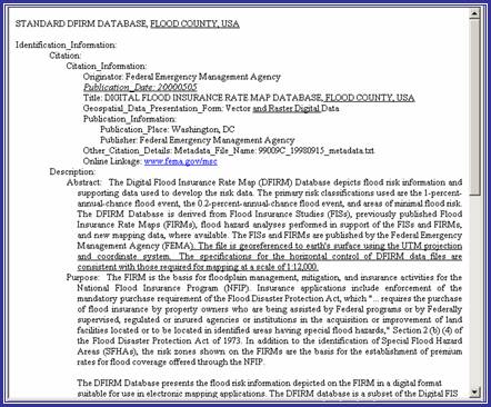
The DFIRM Metadata Builder simplifies the creation of the database metadata document. A metadata file is generated to meet FGDC Content Standards for Digital Geospatial Metadata. The content of the file is based upon the template in FEMA’s Guidelines and Specifications for Flood Hazard Mapping Partners, Appendix L: Guidance for Preparing Draft Digital Data and DFIRM Database and records in the Source Citation lookup table (L_SOURCE_CIT). The metadata document generated is saved to the K: drive within the Document folder, located in Submissions folder for the project.
|
|
| DFIRM Metadata Builder toolbar |
The following is a quick reference guide to all of the components of DFIRM Metadata Builder. All data is required to have a complete metadata file, so you will need to know how to generate and populate a metadata file to meet FGDC standards.
![]()
|
|
Build DFIRM metadata file | Initialize a new metadata file |
|
|
View DFIRM metadata file | View a metadata file |
|
|
Add Source to DFIRM metadata file | Add a new source to an existing metadata file |
|
|
Edit Source in DFIRM metadata file | Edit source information in an existing metadata file |
![]()
This tool generates and populates the metadata file based upon the source citations listed in the Source Citation lookup table (L_SOURCE_CIT).
|
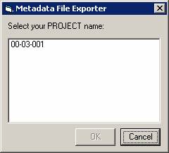
| Project selection dialog |
|
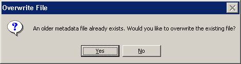
| Confirm overwrite dialog |
NOTE: If the user clicks ‘No’, the metadata tool will terminate. Only one metadata file can exist per DFIRM study.
|
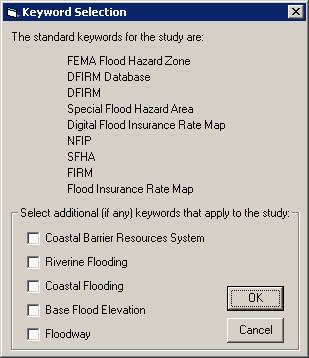
The standard keywords for DFIRM databases are listed, for your reference.
|
| Keyword Selection dialog | |
|
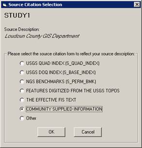
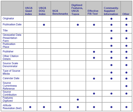
Source Citation name from the Source Citation table Source description from the Source Citation table Select the source citation template that is appropriate for the source listed at the top of the dialog. |
| Source Citation template dialog | |
|
| Required information for each source citation |
|
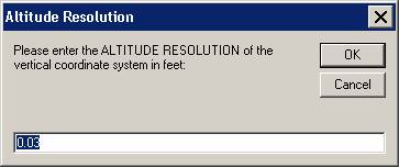
| Altitude Resolution dialog. The default value is 0.03 feet. |
NOTE: If the user clicks a ‘Cancel’ button on any of the dialog boxes presented, the metadata creation process will terminate. No metadata file will be generated.
|
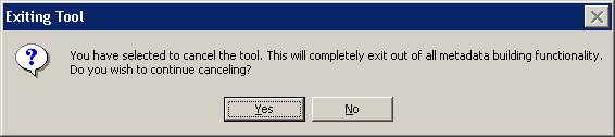
| Confirm exiting metadata tool dialog |
This tool views the metadata file created for the data.
|
|
| Project selection dialog |
NOTE: Only the source citations can be edited (See the section Edit Source in DFIRM metadata file for additional instruction). The entire metadata file must be recreated and the previous file overwritten to revise the keywords and/or the altitude resolution value in the metadata.
This tool evaluates the entries in the Source Citation lookup table (L_SOURCE_CIT) and compares the records to the sources that have been entered in the existing metadata document. If there are sources in the lookup table that do not appear in the metadata file, the user will be prompted to add information for the “new” records.
|
|
| Project selection dialog |

|
| Source Citation template dialog |
NOTE: If the user clicks a ‘Cancel’ button on any of the dialog boxes presented, the metadata source addition process will terminate. No additional source(s) will be populated in the existing metadata file.
|
|
| Confirm exiting metadata tool dialog |
This tool allows the user to edit the information that they entered for each of the source citations referenced in the current metadata file.
|
|
| Project selection dialog |
|
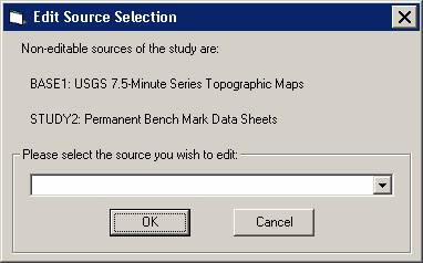
| Edit Source Selection dialog |
NOTE: The source citations that reference USGS Quad Index and NGS Benchmarks are not editable because the user does not enter any additional information into templates for these citations.
NOTE: Only one source can be edited and saved at a time. However, sources can be edited multiple times, as necessary.
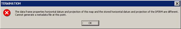
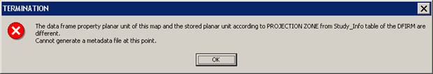
Problem: One or both of the following error messages appeared when I tried to build a metadata file.
|
| Termination message – Data frame projection information does not match Study_Info table projection information. |
|
| Termination message – Data frame units do not match Study_Info table projection information. |
Solution: The value for the field PROJECTION ZONE in the Study_Info table has been changed while you were in the current ArcMap session. Close ArcMap and do not save the .mxd. Relaunch the step in JTX. When ArcMap opens, the data frame projection and datum will be set to the values within your Study_Info table. You should now be able to build your metadata file successfully.
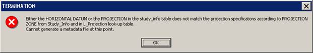
Problem: The following error message appeared when I tried to build a metadata file.
|
| Termination message – Datum, projection, and projection zone information within Study_Info table do not match. |
Solution: The horizontal datum and/or projection in the Study_Info table do not match the projection information designated by the domain value in the PROJECTION ZONE field. To synchronize all of the projection information in the Study_Info table, use the DFIRM Layer Data Loader tool to add the Study_Info table to your project. Enter an editing session, select the record in the Study_Info table, and use the Attribute Selected Features tool on the GeoPop toolbar to edit the Datum, Projection, and Projection Zone values in the Study_Info table to match. Once you have saved the edits to the table, stop editing, and start creating your metadata file again.
Problem: The following error message appeared when I tried to build a metadata file.
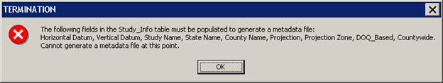
|
| Termination message – Certain fields in the Study_Info table must be populated to generate a metadata file. |
Solution: The metadata tool obtains certain information from the Study_Info table, therefore, specific fields must be populated in order to create a metadata file. To populate any of the fields listed in the error message, use the DFIRM Layer Data Loader tool to add the Study_Info table to your project. Enter an editing session, select the record in the Study_Info table, and use the Attribute Selected Features tool on the GeoPop toolbar to edit the necessary values in the Study_Info table. Once you have saved the edits to the table, stop editing, and start creating your metadata file again.
Problem: The following dialog box appeared when I tried to build a metadata file.
|
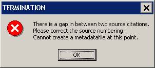
| Termination message – Source citations are not sequential. |
Solution: As sources are created with the GeoPop tools, the source citation IDs are incremented sequentially when more than one record is added for a source type (i.e., Study1, Study2, Base1, Base2). However, if the user deletes a record in a sequential sequence, the Metadata Tool will not allow the user to generate a metadata file. The user needs to manually edit the source citation IDs to ensure that all the source types are numbered sequentially with no omitted numbers.
Problem: The following dialog box appeared while I was creating a new metadata file.
|
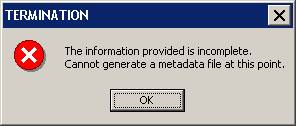
| Termination message – Information is incomplete. |
Solution: If the user exits out of any of the dialogs that appear to collect the required information, the metadata creation process is terminated after the user confirms cancellation of the tool, and the message box above will appear. You must re-start the metadata building process.
Problem: The following dialog appeared when I tried use the USGS Quad Index or NGS Benchmark template for the second time.
|
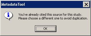
| Information dialog – Source duplication. |
Solution: Each DFIRM study should only have one USGS Quad Index citation and one NGS Benchmark citation.
Problem: The following dialog box appeared when I tried to add a new source to an existing metadata file.
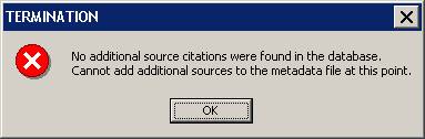
|
| Termination message – No additional sources found. |
Solution: Unless you have added a new record to the Source Citation table (L_SOURCE_CIT), you cannot add a new reference in the metadata file. Use the DFIRM Layer Data Loader tool to add the Source Citation table to your project. Enter an editing session and use the Add New Row tool on the GeoPop toolbar to add a new record to the Source Citation table. Once you have saved the edits to the table, you can stop editing and use the Add Source button on the DFIRM Metadata Builder toolbar to add a new source to the metadata file.
Problem: The following dialog box appeared when I tried to add a new source to an existing metadata file.
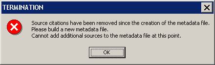
|
| Termination message – Sources have been removed. |
Solution: Once a metadata file is created, sources cannot be removed from the Source Citation lookup table (L_SOURCE_CIT). Removing sources from the lookup table does not remove the associated information in the existing metadata file. If sources are deleted, a new metadata file must be created, overwriting the existing metadata file.
Problem: In the metadata file the publication date and calendar date are listed as ‘prelim’, and the metadata is for an effective study, not a preliminary study.
Solution: If the field EFF_DATE in FIRM Panel Index (S_FIRM_PAN) is blank, then the effective date in the metadata will be populated with ‘prelim’. Populate the field in the FIRM Panel Index attribute table with the appropriate effective date, and recreate the metadata file.
Problem: The following dialog box appeared when I tried to edit a source in the existing metadata file.
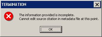
|
| Termination message – Information is incomplete. |
Solution: If the user exits out of the dialog to select an editable source, the metadata editing process is terminated after the user confirms cancellation of the tool, and the message box above will appear. You must re-start the metadata editing process to edit the existing source citation information.
Problem: The following dialog box appeared when I tried to edit a source in the existing metadata file.
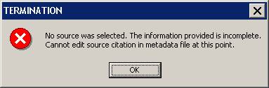
|
| Termination message – No source was selected. |
Solution: When the Edit Source Selection dialog appears, the drop-down window is blank, and the user need to hit the down arrow button to view the list of their source. However, if the user hits “OK”, the error message will appear because no actual source was chosen for editing. You must re-start the metadata editing process to edit the existing source citation information.
Problem: I want to edit the Keywords and/or the Altitude Resolution value in the current metadata file.
Solution: Only the information for individual sources is editable. To change the keywords or altitude resolution in the metadata file, a new metadata file must be created, which overwrites the existing metadata file.
If you need assistance with this tool, please contact the representative at your local RMC.
| NAME | ROLE | PHONE | |
|---|---|---|---|
| REGION I | |||
| Brent McCarthy | Lead | Brent.McCarthy@mapmodteam.com | (336) 240-7339 |
| Jeffrey Burm | GIS/Mapping | JeffBurm@mapmodteam.com | (517) 482-4930 x4752 |
| REGION II | |||
| Rich Cassin | Operations Manager | Rich.Cassin@mapmodteam.com | (914) 333-5366 |
| Michael Crino | GIS/Mapping | mcrino@mbakercorp.com | (718) 482-9945 |
| REGION III | |||
| Mike Conaboy | Operations Manager | mconaboy@mbakercorp.com | (609) 734-7922 |
| Lee Brancheau | Senior GIS Manager | lbrancheau@mbakercorp.com | (609) 734-7912 |
| REGION IV | |||
| Stephen King | Operations Manager | Stephen.King@mapmodteam.com | (678) 459-1010 |
| Kagan Kuyu | GIS/Mapping | Kagan.Kuyu@mapmodteam.com | (678) 459-1041 |
| REGION V | |||
| Sujata Banerjee | Business Manager | Sujata.Banerjee@mapmodteam.com | (312) 575-3902 |
| Pam Coye | GIS/Mapping | Pam.Coye@mapmodteam.com | (312) 575-3913 |
| REGION VI | |||
| Dan Hoecker | Operations Manager | Dan.Hoecker@mapmodteam.com | (940) 783-4155 |
| Phil Nguyen | GIS/Mapping | pxnguyen@mbakercorp.com | (940) 783-4121 |
| REGION VII | |||
| Matthew Koch | Operations Manager | mkoch@watershedconcepts.com | (816) 502-9420 x4952 |
| Rod Odom | GIS/Mapping | rodom@watershedconcepts.com | (816) 502-9420 x4957 |
| REGION VIII | |||
| David Jula | Operations Manager | David.Jula@mapmodteam.com | (720) 514-1100 |
| Mike Garner | GIS/Mapping | Mike.Garner@mapmodteam.com | (720) 514-1105 |
| REGION IX | |||
| Travis Clark | Business Manager | Travis.Clark@mapmodteam.com | (510) 879-0950 |
| Michael Skowronek | GIS/Mapping | Michael.Skowronek@mapmodteam.com | (510) 879-0958 |
| REGION X | |||
| Michael Morgan | Business Manager | Mike.Morgan@mapmodteam.com | (206) 344-3891 |
| Timothy Witten | GIS/Mapping | wittentd@bv.com | (206) 344-3891 |