
What is the Database Exporter?
Quick Reference Guide
Tool Controls
![]() Submit Draft Data
Submit Draft Data
![]() Submit Preliminary Data
Submit Preliminary Data
![]() Submit Final Data
Submit Final Data
Trouble-Shooting
Contacts
The Database Exporter allows users to export the populated data layers and tables from the ESRI SDE Geodatabase format into the three formats Mapping Partners are required to digitally submit to FEMA’s Map Service Center (ESRI shapefile, ESRI Arc/Info interchange file, and MapInfo interchange format). These formats are dictated by FEMA’s Guidelines and Specifications for Flood Hazard Mapping Partners, Appendix L: Guidance for Preparing Draft Digital Data and DFIRM Database. The exported data layers, tables, and log files generated by the Database Exporter are saved to the appropriate folder on the Submittal Directory (K drive).
|
|
| Database Exporter toolbar |
The following is a quick reference guide to all of the components of the Database Exporter Toolbar.
![]()
|
|
Submit Draft Data | Export draft DFIRM data to required formats |
|
|
Submit Preliminary Data | Export preliminary DFIRM data to required formats |
|
|
Submit Final Data | Export final DFIRM data to required formats |
The DFIRM geodatabase must be submitted to FEMA in three digital data formats: ESRI shapefile (.shp); ESRI Arc/Info interchange file (.e00); and MapInfo interchange format (.mif). These formats are exported and stored when the DFIRM database is being developed (Draft Data); when the study is Preliminary (Preliminary Data); and when the study is Post-Preliminary (Final Data).
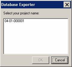
Use this tool to export the draft version of the project data to the three required formats. The exported data files and the export log file are stored in the Submittal Directory (K drive), in the project’s Draft_DFIRM_DB folder.
|
| Project Selection dialog |
NOTE: The data must be exported to all formats once the process is initiated, and the process cannot be canceled. The export may require a considerable amount of time, depending upon how much data exists for the project. Make sure that you are ready to start exporting before selecting your project number.
|
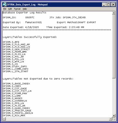
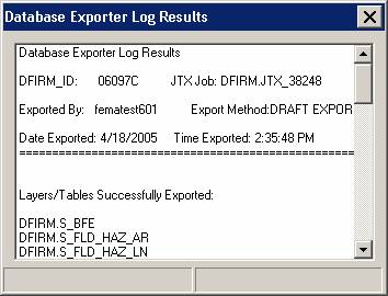
| Database Exporter Results Log |
Use this tool to export the preliminary version of the project data to the three required formats. The exported data files and the export log file are stored in the Submittal Directory (K drive), in the project’s Preliminary_DFIRM_DB folder.
The functionality of the Submit Preliminary Data button is exactly the same as the Submit Draft Data button. Refer to the steps and screen captures in the Submit Draft Data section of this user guide for the exporting procedure.
Use this tool to export the final version of the project data to the three required formats. The exported data files and the export log file are stored in the Submittal Directory (K drive), in the project’s Final_DFIRM_DB folder.
The functionality of the Submit Final Data button is exactly the same as the Submit Draft Data button. Refer to the steps and screen captures in the Submit Draft Data section of this user guide for the exporting procedure.
Problem: This error message appeared when the database was exporting from the geodatabase to the dBase tables.

|
| Error message – Not populated with a valid domain value. |
Solution: When the tables are exported to dBase format, all of the domain codes are converted to domain values. In this case, the field was not populated with a valid domain code; thus, the tool is not able to translate it into a valid domain value. The exporting process will continue when you click OK. After the exporting process is complete, correct the error that the message refers to by selecting a valid value from the domain. Save your edits and repeat the database export.
If you need assistance with this tool, please contact the representative at your local RMC.
| NAME | ROLE | PHONE | |
|---|---|---|---|
| REGION I | |||
| Brent McCarthy | Lead | Brent.McCarthy@mapmodteam.com | (336) 240-7339 |
| Jeffrey Burm | GIS/Mapping | JeffBurm@mapmodteam.com | (517) 482-4930 x4752 |
| REGION II | |||
| Rich Cassin | Operations Manager | Rich.Cassin@mapmodteam.com | (914) 333-5366 |
| Michael Crino | GIS/Mapping | mcrino@mbakercorp.com | (718) 482-9945 |
| REGION III | |||
| Mike Conaboy | Operations Manager | mconaboy@mbakercorp.com | (609) 734-7922 |
| Lee Brancheau | Senior GIS Manager | lbrancheau@mbakercorp.com | (609) 734-7912 |
| REGION IV | |||
| Stephen King | Operations Manager | Stephen.King@mapmodteam.com | (678) 459-1010 |
| Kagan Kuyu | GIS/Mapping | Kagan.Kuyu@mapmodteam.com | (678) 459-1041 |
| REGION V | |||
| Sujata Banerjee | Business Manager | Sujata.Banerjee@mapmodteam.com | (312) 575-3902 |
| Pam Coye | GIS/Mapping | Pam.Coye@mapmodteam.com | (312) 575-3913 |
| REGION VI | |||
| Dan Hoecker | Operations Manager | Dan.Hoecker@mapmodteam.com | (940) 783-4155 |
| Phil Nguyen | GIS/Mapping | pxnguyen@mbakercorp.com | (940) 783-4121 |
| REGION VII | |||
| Matthew Koch | Operations Manager | mkoch@watershedconcepts.com | (816) 502-9420 x4952 |
| Rod Odom | GIS/Mapping | rodom@watershedconcepts.com | (816) 502-9420 x4957 |
| REGION VIII | |||
| David Jula | Operations Manager | David.Jula@mapmodteam.com | (720) 514-1100 |
| Mike Garner | GIS/Mapping | Mike.Garner@mapmodteam.com | (720) 514-1105 |
| REGION IX | |||
| Travis Clark | Business Manager | Travis.Clark@mapmodteam.com | (510) 879-0950 |
| Michael Skowronek | GIS/Mapping | Michael.Skowronek@mapmodteam.com | (510) 879-0958 |
| REGION X | |||
| Michael Morgan | Business Manager | Mike.Morgan@mapmodteam.com | (206) 344-3891 |
| Timothy Witten | GIS/Mapping | wittentd@bv.com | (206) 344-3891 |