
What is the DFIRM Annotation Tool?
DFIRM Annotation Tool Overview
What can you do with the DFIRM Annotation Tool?
Quick Reference Guide
Tool Controls
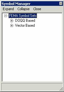
![]() Symbol Manager
Symbol Manager
![]() Line Leader
Line Leader
![]() Dot Leader
Dot Leader
![]() Arrow Leader
Arrow Leader
![]() Vector Gutter
Vector Gutter
![]() DOQQ Line Leader
DOQQ Line Leader
![]() DOQQ Dot Leader
DOQQ Dot Leader
![]() DOQQ Arrow Leader
DOQQ Arrow Leader
![]() DOQQ Vector Gutter
DOQQ Vector Gutter
![]() Interstate Highway
Interstate Highway
![]() US Highway
US Highway
![]() State Highway
State Highway
![]() County Highway
County Highway
![]() Hold Out Interstate Highway
Hold Out Interstate Highway
![]() Hold Out US Highway
Hold Out US Highway
![]() Hold Out State Highway
Hold Out State Highway
![]() Hold Out County Highway
Hold Out County Highway
Trouble - Shooting
Contacts
Appendix A: FEMA Symbol Sets
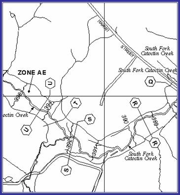
The DFIRM Annotation tool allows the user to add leader lines, highway shields, and other notes on DFIRM maps that are not automatically generated in the batch annotation done with Label Panel. Annotation and leaders can be added for maps with vector or DOQQ bases. The tool creates annotation that meets FEMA’s Guidelines and Specifications for Flood Hazard Mapping Partners Appendix K: Format and Specifications for Flood Insurance Rate Maps and Appendix L: Guidance for Preparing Draft Digital Data and DFIRM Database.
The text, leaders, and other graphics you create with this set of tools are features that are added to the annotation feature class associated with the job. This annotation is stored in the annotation feature classes that hold the Label Panel output. If text is added to a panel, using the DFIRM Annotation tool, the annotation will be “fixed” and will not be overwritten if Label Panel is re-run. Just as leaders generated with the Label Panel tool are re-created each time Label Panel is run, the leaders created with the DFIRM Annotation tool will need to be re-created manually if the panel is re-annotated with Label Panel.
The features available in this tool should only be used after a panel layout has been previewed with Map Production Pro. Once the panel has drawn, the user must switch from Layout View to Data View to begin using the DFIRM Annotation tools.
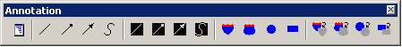 |
| The DFIRM Annotation Toolbar |
This user guide contains useful information that will help guide you in the use of the tool. The key sections of this guide are:
| Use the Symbol Manager to add additional text to the map, according to the type of base used |
|
If the interstate highway shield runs over a line, use the Interstate Highway Hold Out to hide the underlying line. |
|
| Use the Line Leader tool to add a leader for a line feature. | Add an Interstate Highway shield with a hollow fill. | ||
| Add a cartographic gutter to the map with the Vector Gutter tool. | Use the DOQQ Line Leader tool to add a heavy leader for a line feature. |
The following is a quick reference guide to all the tools available on the DFIRM Annotation toolbar. In addition, positioning your cursor over a button on the toolbar will display its name.
|
|
Symbol Manager | Allows user to specify annotation to be added |
|
|
Line Leader | Creates a simple leader line |
|
|
Dot Leader | Creates a leader line with a dot at the terminal end |
|
|
Arrow Leader | Creates a line with an arrow at the terminal end |
|
|
Vector Gutter | Allows user to add a cartographic gutter (symbolized by a white line) |
|
|
Line Leader for DOQQ | Creates a simple leader line for a DOQQ base |
|
|
Dot Leader for DOQQ | Creates a leader line with a dot at the terminal end for a DOQQ base |
|
|
Arrow Leader for DOQQ | Creates a line with an arrow at the terminal end for a DOQQ base |
|
|
Vector Gutter for DOQQ | Allows user to add a cartographic gutter (symbolized by a white line) for a DOQQ base |
|
|
Interstate Highway | Creates an interstate highway label with a hollow background |
|
|
US Highway | Creates a US highway label with a hollow background |
|
|
State Highway | Creates a state highway label with a hollow background |
|
|
County Highway | Creates a county highway label with a hollow background |
|
|
Hold Out Interstate Highway | Creates an interstate highway label with a solid background |
|
|
Hold Out US Highway | Creates a US highway label with a solid background |
|
|
Hold Out State Highway | Creates a state highway with a solid background |
|
|
Hold Out County Highway | Creates a county highway with a solid background |
This section describes the functionality of each of the tools on the DFIRM Annotation toolbar.
Use the Symbol Manager to specify which annotation should be added to your FIRM. Refer to Appendix A in this document for a complete list of the annotation that can be added using this tool.
 |
| Symbol Manager dialog window |
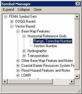 |
| Range, Township Number in the Symbol Manager dialog window |
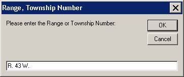 |
| Range, Township Number dialog window |
Add a leader to an existing piece of annotation. The leader style cannot be modified.
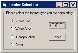 |
| Leader Selection dialog window |
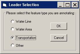 |
| Leader Selection dialog window with Transportation feature type selected. |
Note: It is important to make an accurate leader type selection, as this information is used in the conversion of the annotation layer to the S_Label_Ld layer. The S_Label_Ld layer is required, according to specifications in FEMA’s Appendix L.
Add a leader with a dot ending to an existing piece of annotation. The leader style cannot be modified.
|
|
| Leader Selection dialog window |
|
|
| Leader Selection dialog window with Transportation feature type selected. |
Note: It is important to make an accurate leader type selection, as this information is used in the conversion of the annotation layer to the S_Label_Ld layer. The S_Label_Ld layer is required, according to specifications in FEMA’s Appendix L.
Add a leader with an arrowhead end to an existing piece of annotation. The leader style cannot be modified.
|
|
| Leader Selection dialog window |
|
|
| Leader Selection dialog window with Transportation feature type selected. |
Note: It is important to make an accurate leader type selection, as this information is used in the conversion of the annotation layer to the S_Label_Ld layer. The S_Label_Ld layer is required, according to specifications in FEMA’s Appendix L.
A vector or cartographic gutter is used to denote a boundary between flood hazard zones, for example between an A and an AE zone. This symbol style cannot be modified.
This tool will add a leader to the map with a heavy line weight so that it is more visible on an orthophoto base-map. The line style cannot be modified.
|
|
| Leader Selection dialog window |
|
|
| Leader Selection dialog window with Transportation feature type selected. |
Note: It is important to make an accurate leader type selection, as this information is used in the conversion of the annotation layer to the S_Label_Ld layer. The S_Label_Ld layer is required, according to specifications in FEMA’s Appendix L.
This tool will add a leader with a dot or meatball end with a heavy line weight. It will be more visible on an orthophoto base map. The line style cannot be modified.
|
|
| Leader Selection dialog window |
|
|
| Leader Selection dialog window with Transportation feature type selected. |
Note: It is important to make an accurate leader type selection, as this information is used in the conversion of the annotation layer to the S_Label_Ld layer. The S_Label_Ld layer is required, according to specifications in FEMA’s Appendix L.
This tool will add a leader with an arrow head end with a heavy line weight. The line will be more visible on an orthophoto base map. The line style cannot be modified.
|
|
| Leader Selection dialog window |
|
|
| Leader Selection dialog window with Transportation feature type selected. |
Note: It is important to make an accurate leader type selection, as this information is used in the conversion of the annotation layer to the S_Label_Ld layer. The S_Label_Ld layer is required, according to specifications in FEMA’s Appendix L.
A vector or cartographic gutter is used to denote a boundary between flood hazard zones, for example between an A and an AE zone. This symbol style has a heavy line weight so that it is visible on an orthophoto base map. This symbol style cannot be modified.
The tool adds an interstate highway shield with a hollow fill to the map.
The tool adds a US highway shield with a hollow fill to the map.
The tool adds a State highway shield with a hollow fill to the map.
The tool adds a county highway shield with a hollow fill to the map.
The tool adds an interstate highway shield with a solid white fill to the map.
The tool adds a US highway shield with a solid white fill to the map.
The tool adds a State highway shield with a solid white fill to the map.
The tool adds a county highway shield with a solid white fill to the map.
Problem: You receive an error message that the data is not in a projection.
Solution: You must use the DFIRM Layer Data Loader to add the STUDY_INFO table to the project. Use GeoPop Pro to populate the table with the correct projection information.
Problem: The following error message appears when you try to use a tool.
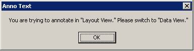
Solution: Switch to the specified view.
Problem: The following error message appears when you try to use a tool.
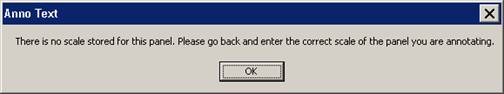
Solution: The SCALE attribute is not populated correctly in the FIRM INDEX layer (S_Fld_Haz_Ar). Use GeoPop Pro to populate the table with the correct scale information.
If you need assistance with this tool, please contact the representative at your local RMC.
| NAME | ROLE | PHONE | |
|---|---|---|---|
| REGION I | |||
| Brent McCarthy | Lead | Brent.McCarthy@mapmodteam.com | (336) 240-7339 |
| Jeffrey Burm | GIS/Mapping | JeffBurm@mapmodteam.com | (517) 482-4930 x4752 |
| REGION II | |||
| Rich Cassin | Operations Manager | Rich.Cassin@mapmodteam.com | (914) 333-5366 |
| Michael Crino | GIS/Mapping | mcrino@mbakercorp.com | (718) 482-9945 |
| REGION III | |||
| Mike Conaboy | Operations Manager | mconaboy@mbakercorp.com | (609) 734-7922 |
| Lee Brancheau | Senior GIS Manager | lbrancheau@mbakercorp.com | (609) 734-7912 |
| REGION IV | |||
| Stephen King | Operations Manager | Stephen.King@mapmodteam.com | (678) 459-1010 |
| Kagan Kuyu | GIS/Mapping | Kagan.Kuyu@mapmodteam.com | (678) 459-1041 |
| REGION V | |||
| Sujata Banerjee | Business Manager | Sujata.Banerjee@mapmodteam.com | (312) 575-3902 |
| Pam Coye | GIS/Mapping | Pam.Coye@mapmodteam.com | (312) 575-3913 |
| REGION VI | |||
| Dan Hoecker | Operations Manager | Dan.Hoecker@mapmodteam.com | (940) 783-4155 |
| Phil Nguyen | GIS/Mapping | pxnguyen@mbakercorp.com | (940) 783-4121 |
| REGION VII | |||
| Matthew Koch | Operations Manager | mkoch@watershedconcepts.com | (816) 502-9420 x4952 |
| Rod Odom | GIS/Mapping | rodom@watershedconcepts.com | (816) 502-9420 x4957 |
| REGION VIII | |||
| David Jula | Operations Manager | David.Jula@mapmodteam.com | (720) 514-1100 |
| Mike Garner | GIS/Mapping | Mike.Garner@mapmodteam.com | (720) 514-1105 |
| REGION IX | |||
| Travis Clark | Business Manager | Travis.Clark@mapmodteam.com | (510) 879-0950 |
| Michael Skowronek | GIS/Mapping | Michael.Skowronek@mapmodteam.com | (510) 879-0958 |
| REGION X | |||
| Michael Morgan | Business Manager | Mike.Morgan@mapmodteam.com | (206) 344-3891 |
| Timothy Witten | GIS/Mapping | wittentd@bv.com | (206) 344-3891 |
When you open the Symbol Manager, the annotation below is available to you, for both Vector and DOQQ-based FIRMs.
DOQQ Based – Has the same options available as for vector-based maps, shown below.
Vector Based
Base Map Features
Horizontal Reference Grids
Range, Township Number
Section Number
Hydrographic
Name of River, Stream, or Other Hydrographic Feature (Small)
Name of River, Stream, or Other Hydrographic Feature (Medium)
Name of River, Stream, or Other Hydrographic Feature (Large)
Unnamed Stream, Unnamed Tributary
Wash or Glacier and Name
Intracoastal Waterway Label
Canal Label
Cranberry Bog Label
Ditch Label
Glacier Label
Marsh Label
Pond Label
Swamp Label
Wash Label
Transportation
Street, Road, Avenue
Private Road Label
Unimproved Road Label
Unnamed Road Label
Road or Railroad Bridge
Footbridge Label
Tunnel Label
Railroad
Abandoned Railroad Label CAPS
Abandoned Railroad Label CLC
Dismantled Railroad Label CAPS
Dismantled Railroad Label CLC
Old Railroad Grade Label CAPS
Old Railroad Grade Label CLC
Ferry Label
Airport / Airfield Name (Small)
Airport / Airfield Name (Medium)
Airport / Airfield Name (Large)
Airfield Label
Landing Strip LabelOther Base Map Feature and Notes
Name of Large Island (Small)
Name of Large Island (Medium)
Name of Large Island (Large)
Name of Small Island (Small) CAPS
Name of Small Island (Small) CLC
Name of Small Island (Large) CAPS
Name of Small Island (Large) CLC
Name of Point, Cape, Neck (Small) CAPS
Name of Point, Cape, Neck (Small) CLC
Name of Point, Cape, Neck (Medium) CAPS
Name of Point, Cape, Neck (Medium) CLC
Name of Point, Cape, Neck (Large) CAPS
Name of Point, Cape, Neck (Large) CLC
Name of Gulch, Canyon, Draw (Small) CAPS
Name of Gulch, Canyon, Draw (Small) CLC
Name of Gulch, Canyon, Draw (Large) CAPS
Name of Gulch, Canyon, Draw (Large) CLC
Corporate Limits Coincident With Shoreline Label
This Area Shown Label
Significant Outlined LandmarkCoastal Barrier Resources System Features and Notes
Flood Insurance Not Available for Structures after Oct 1, 1983 Label
Flood Insurance Not Available for New Construction Label
Flood Insurance Not Available for Structures (Insert date) Label
Coastal Barrier Identified Label
Otherwise Protected Area Identified Label
This Area Contained Within CBRS Label
Comments or Concerns Regarding CBRS LabelFlood Hazard Features and Notes
Flooding Effects From (source name) Label
Floodway in This Area Too Narrow Label
Floodway Contained in Channel Label
Floodway Contained in Culvert Label
This Area Protected From 1% Annual Chance Flood Label
This Area Includes Areas Protected from 1% Annual Chance Flood Label
Coastal Base Flood Elevations Apply Only Landward Label
Flood Hazard Information Not Shown Label
Flood Hazard Information is Shown Within Label
Flood Insurance Information on This Map LabelLOMR
Revised Area Label (Small)
Revised Area Label (Medium)
Revised Area Label (Large)
Area Revised by LOMR Dated Label (Small)
Area Revised by LOMR Dated Label (Medium)
Area Revised by LOMR Dated Label (Large)Map Body Features and Notes
Clarify Coincident With Features
Profile Base Line Label